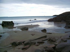
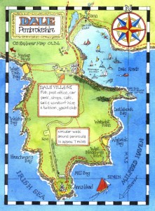
Henry’s rocky cove
In August 1485, so the story goes, Henry Tudor sailed over from exile in France and landed at Mill Bay in Pembrokeshire. Gathering support along the way, he then stomped eastwards, beat up Richard III in the Battle of Bosworth and crowned himself Henry VII. The rest, as they say, is history. Now, here’s the question – why did he land in Mill Bay? We know why he landed in Pembrokeshire; because he was born in Pembroke Castle and wanted to gather men from Wales as he marched, and the English were keeping a watchful eye on the south coast in case he tried to sneak in that way.

I went to Mill Bay last weekend, a pleasant half hour stroll along the coast path from the car park on St Ann’s Head. It’s the first cove on the left as you sail into Milford Haven. The path dips down to the cove where a small valley tips a stream onto a rocky foreshore. You could land a small boat there, but I’d only attempt it in a very flat calm; negotiating the rocks and finding a flat piece of sand to beach would be tricky. Perhaps there was more sand in Mill Bay in the 15th century. Perhaps there was a stone pier. But it’s still an odd choice, as another half an hour’s sail brings you to the glorious sheltered bay of Dale, which is about as perfect as an anchorage and sheltered landing place could be, and would have saved the would-be monarch from an hour’s tramp along the cliffs. Apparently he sent some of his ships round to Dale, but he preferred to be put ashore at Mill Bay. I bet he got his feet wet.
Even more sensible than Dale would have been to save another day’s march and take the tide further upriver, to his birthplace at Pembroke perhaps, or to Milford. Even if the wind was unfavourable, the tide would have carried the fleet upriver very efficiently. Perhaps he had a girlfriend on St Ann’s Head. Perhaps he’d had enough of being afloat and was desperate to get ashore. Perhaps nobody knows, but if you do, please let me know. It’s always interesting to look at history from a seafarer’s point of view.

If Henry’s ship’s log was still around, I’d love to see it. And talking of log books (ouch, what a contrived link!) and with a leap of imagination back into the 21st century, my newly designed Log Books for Little Ships are back from the printers – have a look at www.starfishbooks.co.uk for the details. When I say the books are back from the printers, what I actually mean is that my studio floor has disappeared under several dozen boxes of pages and covers, so there’s just the small business of collating and binding them. In the meantime I’m stepping over boxes to get to my drawing board. Ho hum…

Hi Claudia,
I am never one to pass up a good historical mystery, even if I know nothing about it! But looking at the map and thinking about the Dale peninsula and surrounding terrain, I suspect the answer is more military than nautical. Although Dale Fort is of 19th Centruy construction, the peninsular has obvious strategic advantages. It is relatively easily accesible from the sea, but only in defined and therefore defendable places. Land access is across a relatively narrow section of ground – again, defensible, or al least patrolable.
As for other more hospitable landing places, Henry may well have been uncertain of his welcome and therefore the castle was a potential threat, at least until he had established himself. The Dale peninsular is 20k from the bridge at Pembroke – more than a day’s march for infantry, but just about reachable by horseback, if he wanted to send messengers to test the waters before sending ships and men there to land in greater numbers.
Also, I seem to recall from a distant history, that his main purpose was to gather support from the gentry of the area (including my own purported forefathers) who held rich estates across the Pembroke area.
But from a mariner’s point of view, I can see what you mean. i can just imagine the argument between Henry and the ship’s master (with the latter muttering all the way in about lee shores, deep waters for an anchor, and the lack of insurance!)
Good luck with the research.
O.
Thanks Owen, that makes sense…there also may have been a symbolic element in being put ashore at the first available landing site, as a way of asserting his intentions in staking a claim to the kingdom. Whatever his reasons, it obviously worked. We’ll never know how much getting his feet wet contributed to his success, but it’s the little human details in history that fascinate!
Hi Claudia,
Have you come across the BBC TV film ‘Bus to Bosworth’, made in 1975? Actor Kenneth Griffith led 20 Welsh schoolchildren from Mill Bay to Bosworth Field by coach, telling the story of Henry Tudor’s march to battle in 1485, and visiting all the relevant places along the way. It is a very entertaining and informative film, running for one hour. Hopefully it may be repeated on TV again one day. It was made by BBC Wales at Cardiff, and filmed on location throughout the journey.
With best wishes,
Terry Jones.